RevealEarth Series -- InforShell Digital Product
Roam to any corner of earth in high quality 3D topography visualization
|
|
RevealEarth Series -- InforShell Digital Product
|
|
Reveal Earth 3D - True Color Elevations (One DVD-ROM) -- Contains over 29900 indexed world cities and locations -- DEM database with true color image indexing & visualization -- Easy access to elevation data at 1km ground and 1m vertical resolution RevealEarth - True Color Elevations combines global satellite imagery and elevation data to bring you a vivid view of the planet earth. You will roam a continuous true color image of the world at 1km ground resolution (NASA's Blue Marble, 30 arc-seconds, 1cm:25km, 21600 x 43200 pixels), and view cursor point longitude, latitude and altitude data (GLOBE Digital Elevation Model, 1m vertical resolution). Interactive 3D elevation plots with true color surface texture visually illustrate drainage patterns and elevation trends. The image filter feature will further highlight areas of interest according to your target elevation range. RevealEarth - True Color Elevations is an efficient assembly of geographic data for your reference, teaching or studies. No installation required. System Requirements: MS Windows 2000/XP, DVD-ROM drive. RevealEarth 3D visualization image gallery: North America South America Europe Africa Arabian Peninsula Asia False color visualization |
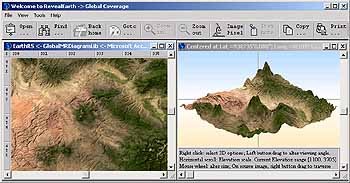 Figure: true color 3D elevation visualization (or false color)
Order from InforShell by check or distributor |
|
|